RHCDA holds four, free group trainings per year for area Community Development Corporations on a variety of topics. Our March 2011 Training focused on the American Community Survey, and specifically the 2005-2009 data.
MAPC Data Services provided data and technical assistance for March’s 2010 Census release. Leading up to the release Holly St. Clair presenting around the region on the ACS and 2010 Census releases, helping municipalities to understand the difference between the 2000 Census and the 2010 data. MAPC issued guidelines for municipalities and reporters around the use of ACS data and basic maps and tables for 2010 Redistricting Data release and worked with Boston Globe Reporters.
This fact sheet, prepared for the Washington Area Women's Foundation, updates poverty data presented last year to coincide with the release of the Portrait of Women and Girls in the Washington Metropolitan Area report. Estimates are from the 2010 American Community Survey and document the increase in poverty rates for women and girls throughout the region, the high levels of poverty in the District of Columbia, and the dramatic growth in numbers of poor women and girls in suburban Prince George's County, Maryland.
In partnership with Urban Institute, we convened a group of key policy makers around the third edition of Housing in the New Orleans Metro Annual Report, “Drivers of Housing Demand”. Speakers included Kathy Petit and Chris Narducci from the Urban Institute, and Allison Plyer and Elaine Ortiz from GNOCDC.
(Inactive) Center for Community Building and Neighborhood Action (Memphis)
April 2012
Originally funded by a grant from the US Department of Justice and designed by CBANA/C3R (working with the Southeast Memphis CDC and Ledic Asset Management) , “Safeways” is a data-driven supportive collaboration among owner/managers, residents, law enforcement, and non-profits to improve safety and quality of life in multifamily housing communities. Owners/managers access training and technical assistance in place management and resident services, and may apply for Safeways Certification.
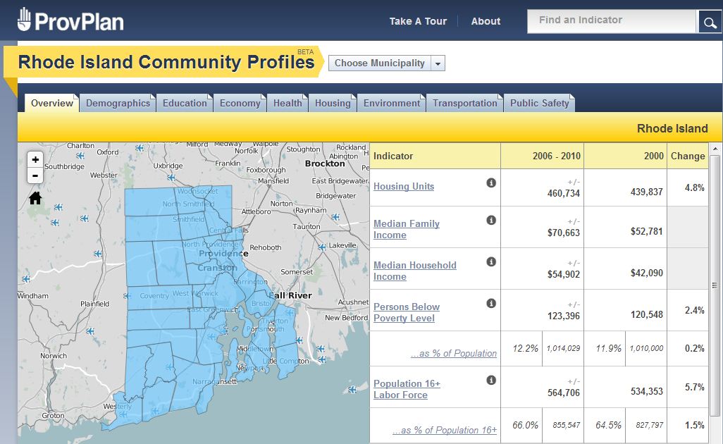
For almost a decade the Providence Neighborhood Profiles have been a critical resource for government, community organizations, and people simply interested in learning about the City. With generous funding from the Rhode Island Foundation and Rhode Island Statewide Planning Program, ProvPlan has developed a new site - Rhode Island Community Profiles - that provides a host of statewide information.
The Urban Institute, and GeoLytics, Inc., a private firm specializing in the development of demographic and geographic data products, are producing an update of an important data resource that will enable policymakers, community organizations, and researchers to examine and analyze changes that have occurred in U.S. neighborhoods over the past four decades.
Over the next 12 months Public Health- Seattle & King County will be developing new data profiles for 22 cities and unincorporated areas of King County. The profiles will include up-to-date demographics and measures of behavioral risks, access to care, health status, fertility, birth risk factors and mortality. Presented in a series of charts and tables, measures for the city—and, if the city is large enough, each neighborhood-- will be compared to King County and Washington State averages.
Our new HRA boundaries match exact city boundaries, which often are not consistent with ZIP codes, census tracts or block groups. Developing data from sources that only include these other geographic units provided a challenge.
Center on Poverty and Community Development (Cleveland)
March 6, 2012
The Poverty Center's Neighborhood Stabilization Team Web Application (NST Web App) was selected as a Leadership in Community Innovation Award finalist. Four finalist groups competed for the award which included $25,000, funded by Key Bank, to go toward continuing projects. While the Center did not win the final award, it was an honor for the NST Web App to be recognized and selected as a finalist.
Dorothy A. Johnson Center for Philanthropy (Grand Rapids)
2014 - 2015
The Community Research Institute has released the first phase of Community Profiles 2.0 for the Grand Rapids area. This phase aims to build upon CRI's existing work in housing and economics within the City of Grand Rapids.
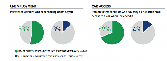
Funded by SCRCOG, and led by SCRCOG, the New Haven NAACP, and Workforce Alliance, the Transportation Study examined the link between transportation and employment, including commuter patterns, bus system reach, barriers to employment, demographics, customer service perceptions, and regional urban development. The Study includes focus groups, surveys, and a public engagement component.
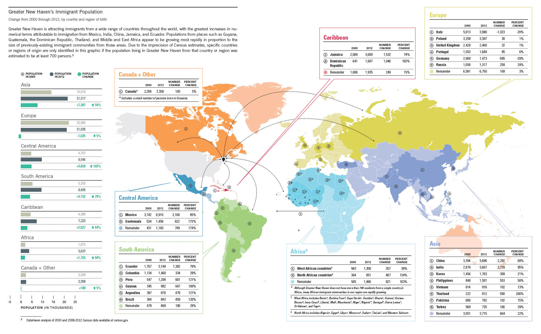
Funded by the Community Foundation for Greater New Haven, the Immigration Study, "Understanding the Impact of Immigration in Greater New Haven," examines patterns in immigration in the Greater New Haven and Connecticut area over the past few decades, as well as the impact of immigration on the region's economy and civic life. Compiling data from state and federal sources as well as local surveys, the report serves as a public resource and data compendium on the issue.
Last week we were awarded an implementation grant from the Aspen Forum for Community Solutions for our Oakland-Alameda County Opportunity Youth Initiative.
Public Health – Seattle & King County (PHSKC) is developing an Automated Disease Surveillance (ADS) program using Stata statistical software. In addition to being able to analyze the health data of multiple record types (e.g., deaths, surveys, hospital discharge), the program also produces summary reports in various formats such as pdf, html or in an export format for use in data visualization packages such as Socrata. Reports can include tables, maps, charts, or other graphics as desired. PHSKC is developing the ADS program collaboratively, enabling multiple PHSKC epidemiologists to
On behalf a broad collaborative of organizations convened by the United Way of Comal County, CI:Now is conducting a broad secondary data assessment of community needs in Comal and Guadalupe Counties, with a special focus on health.
Institute for Urban Policy Research (Dallas) (Inactive) Children's Optimal Health (Austin*) (Inactive) Institute of Portland Metropolitan Studies (Portland)
Event Name:
NNIP Partners Meeting, October 2014
Date of Publication:
October 23, 2014
Institute for Urban Policy Research (Dallas) (Inactive) Children's Optimal Health (Austin*) (Inactive) Institute of Portland Metropolitan Studies (Portland)
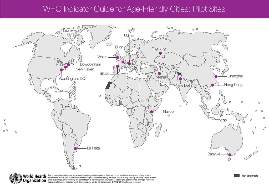
DataHaven is piloting the World Health Organization's (WHO) Age Friendly Communities Indicator Guide for Connecticut. The pilot study is supported by Connecticut's Legislative Commission on Aging, Connecticut Council for Philanthropy, and Connecticut Community Foundation.
Capital One philanthropic mission includes a comprehensive giving program to help build the future of communities for Capital One’s customers and associates across the U.S. These programs, known as Placed Based Initiatives (PBI), can be found in communities in Louisiana, New Jersey, New York, Texas, Virginia, and Washington D.C. Each PBI offers support and development based on the community’s individual and unique needs through strong, collaborative partnerships with organizations, businesses, and community members within the neighborhood.
In Spring 2014, Mayor of Dallas Mike Rawlings gathered the Dallas community and created a Task Force to advise him on substantive, short-term plans to take action against poverty within the city. Dallas, which has the third-highest poverty rate for a city with a population of more than 1 million in the country, faces unique poverty challenges, which continue to disproportionately affect people of color. From 2000 to 2012, Dallas’ poverty increased by 41%, while the population of the city itself overall grew only by 5%. Dr.
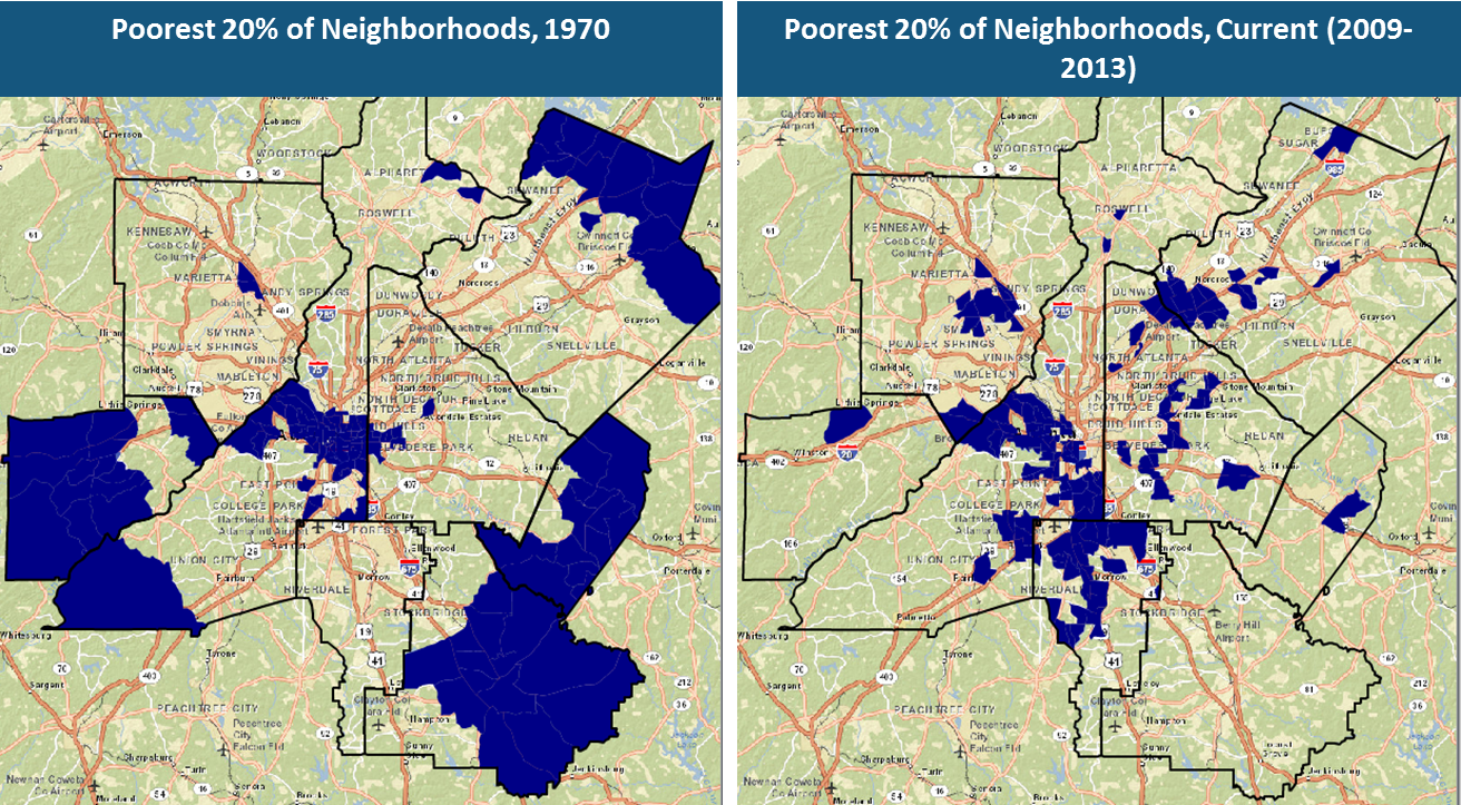
(Inactive) Institute of Portland Metropolitan Studies (Portland) (Inactive) Shift Research Lab (Denver*) Neighborhood Nexus (Atlanta)
April 2014
Equity mapping uses GIS technology to make the connection between so-called areas of opportunity — places where jobs are relatively plentiful and access to education, healthcare, and other amenities is close at hand — and communities with high concentrations of low-income and minority residents.
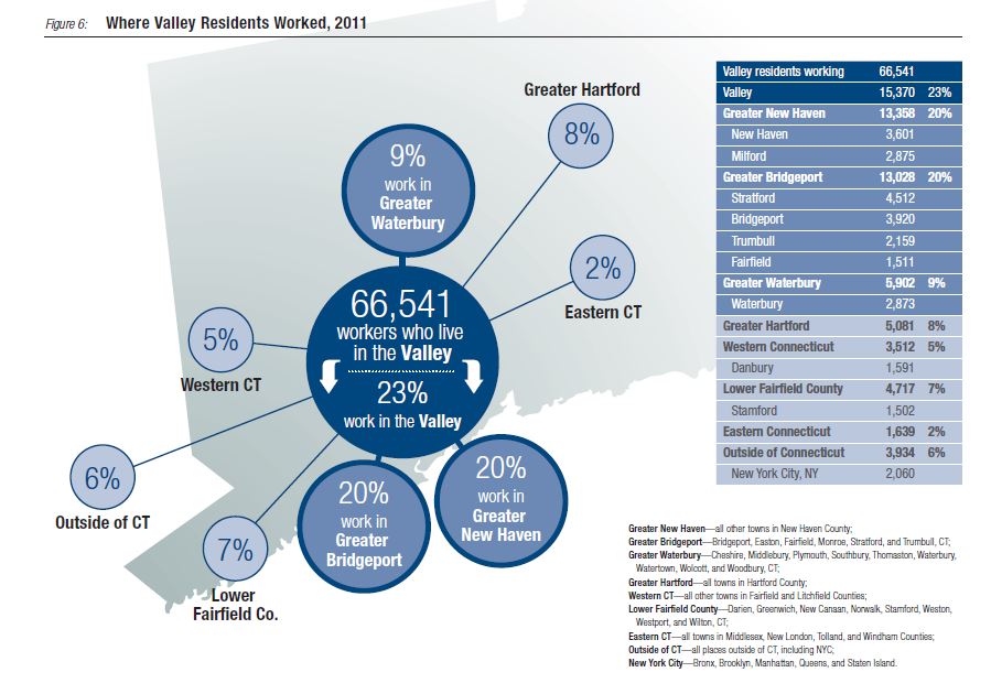
Working with the Valley Community Foundation and approximately 20 other local partners, DataHaven produced a baseline indicators report on the Lower Naugatuck Valley region in 2015. DataHaven is now working with these partners on a longer indicators report, which will also function as a Community Health Needs Assessment for the region. The longer report is scheduled for publication in mid-2016.
DataHaven is working with local partners to develop a comprehensive indicators program for Fairfield County and surrounding areas, utlizing various data sources including DataHaven's 2015 Community Wellbeing Survey, which interviewed approximately 17,000 residents statewide including over 5,000 in Fairfield County and surrounding areas.
This session was conducted by NeighborhoodInfo DC for a group of local area nonprofits who are partipating in the Measure4Change learning community. The purpose of the session was to show groups how accessing data outside of their organization could be valuable to help them assess the needs of the populations and communities they are serving and to report on their results.
Camille Seaberry from DataHaven will demonstrate how to work with the ACS R package to use the Census API to download and run ACS data. Join the webinar to see the demo, ask questions, and share your thoughts on ways to be more efficient in updating the ACS!
Urban Institute recently released two new guidance documents to to build the capacity of communities to use data to address health and improve fair housing and access to opportunity. Both guides draw on the experiences of NNIP and its Partner organizations.
The Urban Institute, the Coalition for Nonprofit Housing and Economic Development (CNHED), Code for DC, and the DC Department of Housing and Community Development hosted an event for the release of the new Housing Insights website that will put better information in the hands of decisionmakers and advocates for affordable housing. Housing Insights will make it easy to browse a list of all subsidized affordable housing in DC, regardless of what subsidy program they are part of.
In recent years, DataWorks staff have done mapping and responsive data projects for groups like the InterNeighborhood Council, Durham City Council, the Northeast Central Durham Leadership Council, Durham CAN, local journalists and researchers, as well as the Durham Open Space and Trails Commission (DOST). The latter, a citizen advisory group, has used maps prepared by DataWorks to know whether proposed pedestrian and bicycle trail routes would assist families without cars, and to understand the commuting patterns for people who live in the proposed trail areas.
The Greater Hartford Neighborhood Data Hub program, managed by DataHaven, is designed to support the more effective curation, collection, sharing, and use of local-level cross-sector data within Hartford. This public service program creates a sustainable and independent entity to measure improved outcomes and reduced inequities using accurate and impartial data on the region and its neighborhoods.
Excerpt on new DataHaven / Community Foundation report from The Day, New London: A recently released report commissioned by the Community Foundation of Eastern Connecticut details inequities faced by women in New London and Windham counties in the realms of economic security, education, health and well-being, and leadership.
Related Links:
New report details inequities for women in eastern Connecticut
Across the Indianapolis region, neighborhoods have experienced rapid cultural changes and shifting housing demand. In June, The Polis Center facilitated a community conversation about neighborhood-level demographic changes across the region from 1970 to today, exploring the trends of suburbanization, gentrification, and suburban redevelopment.
The project “Mapping Displacement Pressure in Chicago Neighborhoods” illustrates how the Institute of Housing Studies helps people across sectors better understand neighborhood dynamics. Staff developed an indicator to identify neighborhoods at risk of rapid price appreciation, lost housing affordability, and potential displacement.
The Institute for Housing Studies conducted a housing market segmentation analysis of the seven-county region surrounding Chicago, IL, in collaboration with the Chicago Metropolitan Agency for Planning, the Metropolitan Mayors Caucus, and the Metropolitan Planning Council. IHS worked with DePaul’s Department of Predictive Analytics to develop a clustering algorithm to identify communities with similar characteristics regardless of physical proximity.
The City of Chicago commissioned the Institute for Housing Studies to develop data to guide conversations around developing Chicago’s 2019-2023 Five-Year Housing Plan. These data informed a series of three Advisory Group meetings held in June and July 2018 where stakeholders were convened to discuss key housing challenges facing the city and recommend potential solutions.
IHS analyzed which Chicago neighborhoods are adding or losing households at different income levels, broke down some of the different patterns and trends that emerge from the data, and let users explore the variation in Chicago neighborhoods through charts and an interactive map.
Related Links:
Understanding Household Income Shifts in Chicago Neighborhoods
IHS looked at data on where the under-18 population in Chicago is growing or declining. We talked to key neighborhood stakeholders to understand why and what these trends mean for neighborhoods.
Related Links:
Why Some Chicago Neighborhoods Are Losing Their Children
Data Driven Detroit has been examining the impact of COVID-19 on education and employment in a blog series. Most recently, they have been analyzing how schools and childcare facilities are responding to pandemic-related regulations and precautions.
Related Links:
Household Experiences: COVID-19's Continued Impact on Parents and Children
In August, Urban Harvest launched its mobile market to bring healthy and affordable food options to underserved areas with limited access to fresh fruits and vegetables. The nonprofit collaborated with the Kinder Institute’s Houston Community Data Connections to create a data-based decision support tool that helps ensure the mobile market is being dispatched to areas of Houston where residents need it the most.
BNIA's new map sheds light on the geography of disconnection in Maryland. A two-thirds majority of disconnected Marylanders live in metro counties or Baltimore City. 40% of all Marylanders without wireline broadband are African American and the figures are similar for computer ownership of any kind (i.e., desktop, laptop, or tablet). Overall, nearly three-quarters of all disconnected Maryland households have incomes below the state’s median income. The map shows where high-speed internet subscription gaps are greatest - and by how much.
Earlier this month, DataHaven and the Fairfield County, Greater Hartford, and Greater New Haven Community Foundations hosted a statewide event to release these landmark publications on quality of life. Each book contains nearly 100 pages of data graphics, maps, and tables, discussing the most meaningful social and economic issues that face Connecticut today, including family economic security, housing, health and safety, criminal justice, education, and much more.
Contact:
Mark Abraham
Related Links:
DataHaven and partners release the 2023 Community Wellbeing Index at the Connecticut State Capitol
The DataHaven Town Equity Reports provide access to relevant town-level information that is not available from any other source. They use new methods to disaggregate data from the 2020 Census, American Community Survey microdata files, DataHaven Community Wellbeing Survey record-level files from 2015 through 2021, and federal and state agency databases.
Related Links:
2023 Equity Reports for all 169 Connecticut Towns, Join our statewide Advisory Council
Staff from two NNIP partner organizations presented at the Association of Public Data Users (APDU) conference, educating a national audience about the power of local data and being in relationship with collaborators in the interest of ensuring all neighborhoods are places where people can thrive.
Exploring the Current Practices, Benefits and Risks of Collecting Data on Sexual Orientation and Gender Identity
Recent research shows trail networks help achieve climate resilience, improve public health, and increase economic prosperity. The Mid-Ohio Regional Planning Commission (MORPC) provided data and analysis to help local governments understand the regional impact of the Central Ohio Greenways (COG) trail system and establish criteria to prioritize trails to fund and build that included equity as a key component.
Data Driven Detroit (D3), Urban Institute, The Data Center
Thursday, September 15, 2022 to Tuesday, December 31, 2024
Over the past two years, the NNIP Network has elevated how local data are critical tools for communities to address the racial wealth gap and improve racial ...
Data Driven Detroit (D3), Urban Institute, The Data Center
Thursday, September 15, 2022 to Tuesday, December 31, 2024
Over the past two years, the NNIP Network has elevated how local data are critical tools for communities to address the racial wealth gap and improve racial ...
Data Driven Detroit (D3), Urban Institute, The Data Center
Thursday, September 15, 2022 to Tuesday, December 31, 2024
Over the past two years, the NNIP Network has elevated how local data are critical tools for communities to address the racial wealth gap and improve racial ...
Allison Plyer (the Data Center in New Orleans) and Laura McKieran (CINow in San Antonio) share strategies for presenting imperfect data to help audiences interpret and use the data appropriately. We want to be responsible when communicating issues such as uncertainty in survey estimates, changes in collection methods, and the limitations of data.


