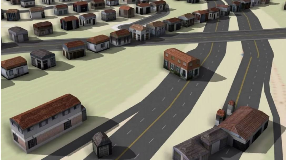
The viaduct that supports I-84 as it passes through Hartford is at the end of its useful life. The community, along with the State Department of Transportation, came together to discuss plans for replacing it as shown in this video
Related Links:
Interstate 84 Viaduct Study Community Summit Video
(Inactive) The Neighborhoods Resource Center (Nashville)
May 2011
NRC continued to improve GettingtoWork.Net, a website showing job training and services needed by low-income job seeker and an interactive map showing the locations of services, child care, transit lines, groceries, etc.
Mapping interface improvements with Mappler used the Google Maps API and have a familiar “look and feel” to users. [See GettingToWork.COM for draft site, to be transferred to GettingToWork.NET.] Final improvements are awaiting notice of funding from Jobs Access and Reverse Commute program of the Federal Transit Administration.
(Inactive) Chicago Metropolitan Agency for Planning (Chicago)
May 2011
CMAP will soon begin implementing its Sustainable Communities grant (HUD) by providing technical assistance for municipal planners across our region. CMAP’s online data systems will serve as background information to guide local planning and development processes at the municipal level.
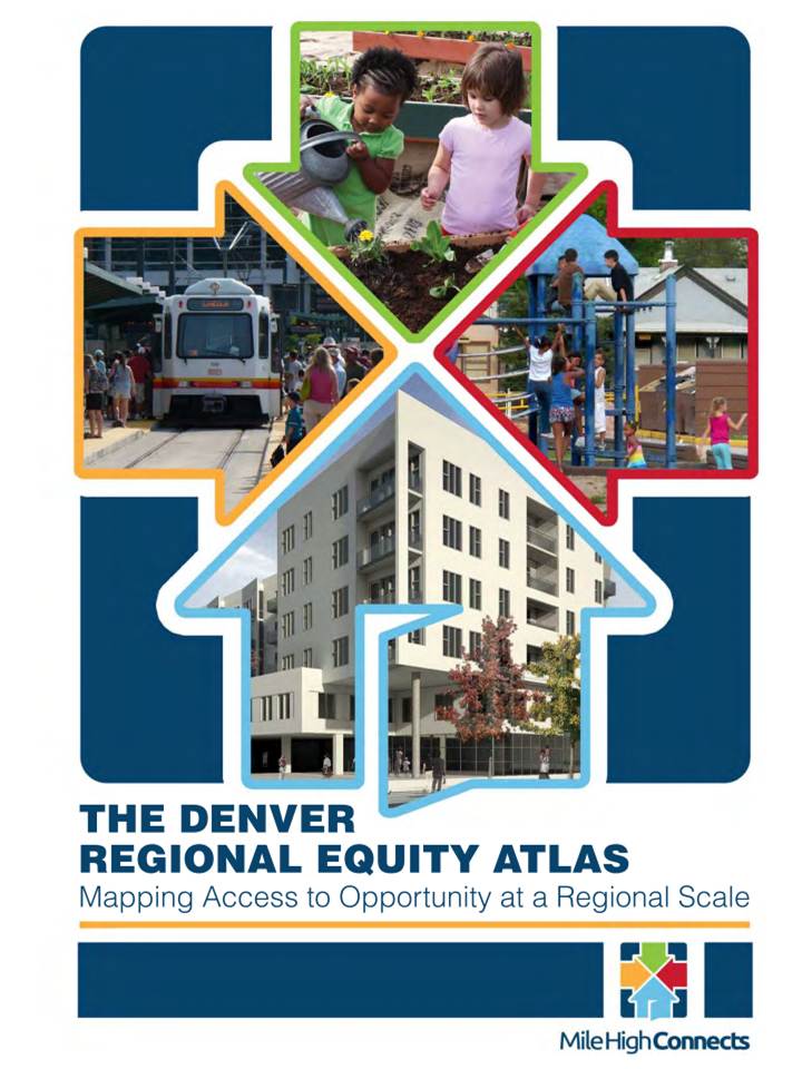
Through a new regional transit-oriented development collaborative, Mile High Connects, supported through the Ford Foundation’s Metropolitan Opportunities Initiative, Piton, partnered with Reconnecting America to develop a regional equity atlas to raise awareness among a wide range of stakeholders about the current lack of access to opportunity for metro Denver’s low‐income residents.
BNIA-JFI is providing both services and analyses as part of a joint proposal with the Job Opportunities Task Force to the Surdna Foundation. The services include: GIS and policy analysis; creating a database of employers located along the proposed Red Line; and creating an occupational analysis of key Red Line employers.
Detroit is developing light rail along the Woodward Corridor. Data Driven Detroit provides the M1 partners with neighborhood indicator analyses and mapping to support the planning process and to benchmark critical indicators.
D3 designed a questionnaire used to gather data about unmet senior mobility needs, including information on their travel patterns, modes of transportation, use of available transit, attitudes toward the public bus systems in Southeast Michigan, and satisfaction with their personal mobility. D3 provided analysis of the questionnaire data throughout the eighteen months of the project.
D3 prepared a profile of the M1 Corridor along Woodward for the Downtown Detroit Partnership. The profile is a collection of baseline indicators intended to inform current planning efforts and support local capacity to measure future change. The profile outlines resident, workforce, business, retail, and limited housing market characteristics for the three M1 Woodward Corridor areas: the Central Business District, Midtown, and the North End/New Center area.
Children's Optimal Health is excited to share the Transportation Related Child Injury mapping initiative to be presented by Children’s Optimal Health and Dell Children’s Medical Center. We hope to connect professionals, community members and advocates to collaboratively inform and facilitate improvement in child injury prevention processes, policies, and services. You are invited and encouraged to Register now.
Growing Transit Communities will help local communities make the most of new light rail service, bus rapid transit and other transit investments, with the goal of putting jobs and opportunity closer to where people live. The result will be communities that all people can afford to live in, where they can walk or take a train or a bus to work, and have good access to shopping and other activities. Making sure that transit investments and the changes that come with them are as balanced and fair as possible, Growing Transit Communities mobilizes residents and community groups representing di
The Data Services department is working with the Town of Marshfield Housing Partnership and Planning Board to estimate the potential build out of commercial and residential properties. Based on existing zoning regulations and other development constraints, the CommunityViz scenario modeling platform is being used to map future dwelling units and commercial square footage. MAPC staff presented preliminary results at the Planning Board meeting on May 14th, which generated valuable feedback from members of the board and the Housing Partnership.
MAPC created an interactive online tool called the MBTA Budget Calculator, accessible at FixTheT.mapc.org, inviting the public to try their hand at balancing the Massachusetts Bay Transportation Authority’s budget. The goal of the MBTA Budget Calculator was to educate the public on the variety of measures that could be taken to solve the MBTA’s massive FY13 budget shortfall and demonstrate that there are alternative solutions to balance the budget while maintaining the current level of service and avoiding drastic fare increases.
Children's Optimal Health is pleased to announce that we have launched a new website. Many of our maps and all of our published reports are available for download through the site. There is currently no charge for these products, but users are asked to register and let us know how they use our work. Children's Optimal Health works to improve operations, impact policy, engage the community and support research to improve the health and well-being of all children in Central Texas.
PlanningCamp is an unconference in Oakland sponsored by the Urban Strategies Council and OpenPlans for those working at the intersection of technology and the hard effort of making better cities -- on the technology side, or the planning side, or a bit of both.
Children's Optimal Health (COH) and Dell Children's Medical Center (DCMC) are excited for the success of their second Transportation-Related Child Injury summit. This event brought together members of the central Texas community to unveil new COH maps highlighting geographic priority areas for child injury intervention and to discuss the next steps to improve local outcomes in child safety.
Children's Optimal Health (COH) and Dell Children's Medical Center (DCMC) are excited for the success of their second Transportation-Related Child Injury summit. This event brought together members of the central Texas community to unveil new COH maps highlighting geographic priority areas for child injury intervention and to discuss the next steps to improve local outcomes in child safety.
Join equity advocates from around the region for a discussion about the region’s key equity priorities, highlighting actions that are being taken – and those that need to be taken – to create a more equitable region. This event will feature keynote remarks by Angela Glover Blackwell, Founder and CEO of PolicyLink, as well as the release of MAPC’s State of Equity in Greater Boston Policy Agenda.
Local advocates will offer remarks on four of the Agenda’s particularly significant recommendations:
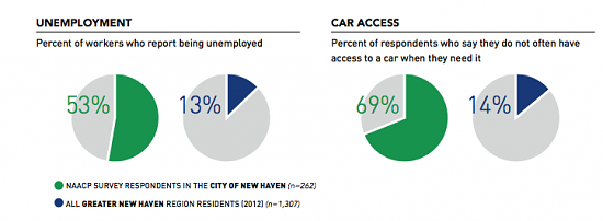
Funded by SCRCOG, and led by SCRCOG, the New Haven NAACP, and Workforce Alliance, the Transportation Study examined the link between transportation and employment, including commuter patterns, bus system reach, barriers to employment, demographics, customer service perceptions, and regional urban development. The Study includes focus groups, surveys, and a public engagement component.
SA2020 is a community visioning and collective impact initiative focused on 11 cause areas. CI:Now collects and analyzes the data to report indicators of progress in these areas, also working to shed light on critical disparities by race/ethnicity, gender, age group, and neighborhood.
In May 2014, D3 launched the 2014 One D Scorecard, an online tool that reports on the status of our region through key data indicators in five Priority Areas: Economic Prosperity, Educational Preparedness, Quality of Life, Social Equity, and Regional Transit. The One D Index also rolls up the over 30 outcome-based indicators composing the five Priority areas into a single comprehensive score to better understand how metro Detroit stacks up across priority areas and other regions overall.
In Spring 2014, Mayor of Dallas Mike Rawlings gathered the Dallas community and created a Task Force to advise him on substantive, short-term plans to take action against poverty within the city. Dallas, which has the third-highest poverty rate for a city with a population of more than 1 million in the country, faces unique poverty challenges, which continue to disproportionately affect people of color. From 2000 to 2012, Dallas’ poverty increased by 41%, while the population of the city itself overall grew only by 5%. Dr.
On October 15, 2010, HUD Regional Administrator Richard Walega announced a $4 million Press conference announcing award of Sustainable Communities grant to MAPCSustainable Communities Grant award for MAPC, on behalf of the Metro Boston Consortium for Sustainable Communities, a coalition created to implement the grant's planning work.
In September 2011, ARC, in partnership with a consortium of 11 other organizations, submitted an application for funding to the U.S. Department of Housing and Urban Development’s Sustainable Communities Regional Planning Grant Program. The Program supports metropolitan and multijurisdictional planning efforts that integrate housing, land use, economic and workforce development, transportation, and infrastructure investments, in line with the six Livability Principles of the federal Partnership for Sustainable Communities.
Institute for Urban Policy Research (Dallas) Data Driven Detroit (D3) (Detroit) (Inactive) Shift Research Lab (Denver*)
October 2015
On October 20th, one day prior to the opening of the Fall NNIP meeting, the Institute for Urban Policy Research, Capital One, and the Collin County Business Alliance (CCBA) convened a group of experts to discuss regional planning and the future of Collin County, which includes most of Dallas' northern suburbs.
In 2014, we began holding virtual idea showcases after partners expressed the desire for more NNIP conversations between in-person meetings. Thanks to Idea Showcases, partners have shared their work and found new opportunities for collaboration with fellow NNIPers.
NNIP HQ started with a quick update on network activities including details about upcoming conferences and overall NNIP goals. Then, each presenter had 5 minutes to talk about potential, current, or completed work.
Building on recent research reports by LINK Houston, the Kinder Institute for Urban Research, and Bike Houston about safety for pedestrians and bicyclists on Houston’s streets, this summit will provide practical, relatable examples of how Houston can improve walkability and biking in Houston.
Dian Nostikasari, a senior research fellow at the Kinder Institute, discussed two reports titled “Planning from Inside Out: Using Community Responses to Address Transportation, Infrastructure and Safety Concerns” and “Safe Streets, Safe Communities: Walking and Biking Infrastructure in Gulfton.”
Between 2010 and 2017, 149 people were killed or injured while walking in the Gulfton neighborhood of Houston. These dangerous pedestrian conditions limited the ability of residents of the majority-immigrant community to safely get to school, work, or places for exercise.
Data Driven Detroit (D3), Urban Institute, The Data Center
Thursday, September 15, 2022 to Tuesday, December 31, 2024
Over the past two years, the NNIP Network has elevated how local data are critical tools for communities to address the racial wealth gap and improve racial ...
Data Driven Detroit (D3), Urban Institute, The Data Center
Thursday, September 15, 2022 to Tuesday, December 31, 2024
Over the past two years, the NNIP Network has elevated how local data are critical tools for communities to address the racial wealth gap and improve racial ...
Data Driven Detroit (D3), Urban Institute, The Data Center
Thursday, September 15, 2022 to Tuesday, December 31, 2024
Over the past two years, the NNIP Network has elevated how local data are critical tools for communities to address the racial wealth gap and improve racial ...
The Institute for Housing Policy is collaborating with local partners in Chicago to identify changing community needs and new priorities that have emerged from the COVID-19 pandemic and recent
MORPC facilitates the planning and development of the region’s multi-use trail network. The Central Ohio Greenways (COG) Regional Trail Vision calls for 500+ new miles of trails to be added to the existing network of over 230 trail miles, resulting in an interconnected network that meets both transportation and recreation needs.
Center for Urban and Regional Analysis (CURA) (Columbus)
October 4, 2022
Image:
CURA has launched the Ghost Neighborhood of Columbus project to help people understand what was destroyed by urban highway construction in the 20th century, and support research on reconstruction of the wealth, vitality and activities that have vanished.
Data reveals that within Marion County, older residents tend to live in areas where the least amount of public transit is available. Census tracts with the greatest population of adults aged 65+ also have the greatest average distance to travel to public bus stops. Plans to expand IndyGo from 2023-2027 will likely improve transit options for some older adults in Marion County, but limited transit opportunities may persist in several areas where older adults reside. In addition, transportation inequities will likely persist in the suburban and rural areas beyond Marion County.
The Blue Line Extension, which will expand the light rail northwest from downtown Minneapolis to North Minneapolis, Robbinsdale, Crystal, and Brooklyn Park, has been planned for over a decade. During this time, communities along the corridor have been organizing to fight for antidisplacement measures and to ensure residents benefit from any development, highlighting that “it’s not about the train, it’s about the people.”
Recent research shows trail networks help achieve climate resilience, improve public health, and increase economic prosperity. The Mid-Ohio Regional Planning Commission (MORPC) provided data and analysis to help local governments understand the regional impact of the Central Ohio Greenways (COG) trail system and establish criteria to prioritize trails to fund and build that included equity as a key component.
Data Driven Detroit (D3), Urban Institute, The Data Center
Thursday, September 15, 2022 to Tuesday, December 31, 2024
Over the past two years, the NNIP Network has elevated how local data are critical tools for communities to address the racial wealth gap and improve racial ...
Data Driven Detroit (D3), Urban Institute, The Data Center
Thursday, September 15, 2022 to Tuesday, December 31, 2024
Over the past two years, the NNIP Network has elevated how local data are critical tools for communities to address the racial wealth gap and improve racial ...
Data Driven Detroit (D3), Urban Institute, The Data Center
Thursday, September 15, 2022 to Tuesday, December 31, 2024
Over the past two years, the NNIP Network has elevated how local data are critical tools for communities to address the racial wealth gap and improve racial ...