D3 was awarded a grant from The Erb Family Foundation to collect environmental data in Detroit. D3 is partnering with various environmental community groups for data collection and sharing purposes. Indicators include recycling facilities, community gardens (asset mapping), and other relevant environmental data. The data will be used to help improve environmental quality and improve transparency surrounding environmental indicators.
Data Driven Detroit and the Graham Sustainability Institute have partnered to initiate the Detroit Sustainability Indicators Project. The project aims to gather and assess data on relevant sustainability related topics (environmental, economic and social), with the intent of mapping these data and making the findings available to the public, and to create a sustainability index for Detroit that will help inform policy and decision making and serve as a model for other urban areas working on sustainable redevelopment.
Urban Strategies Council was selected as the host for the Oakland Emerald Cities Collaborative (OECC). This project will establish Oakland as a continuing leader in the growing movement to combat climate change and ensure that the green economy comes in the form of new opportunities for Oakland's residents and businesses.
D3 is partnered with the Graham Environmental Sustainability Institute at the University of Michigan to establish the Detroit Sustainability Indicators Project, an initiative to measure the city’s sustainability based on environmental, economic and social factors. The two main goals of this project are: 1) gather and analyze data on sustainability issues and make this information available for public use and 2) create a sustainability index for Detroit that will drive informed decision-making and serve as a model for other urban areas pursuing sustainable redevelopment.
D3, with funding from the Erb Family Foundation, undertook to collect, map, and improve community access to, and understanding of, environmental data. D3 is collaborating with several local environmental community organization to collect and manage data. D3 is collaborating with the Sierra Club’s Great Lakes Chapter to gather green water infrastructure data, with the goal of showing the effects of rain barrels, rain cisterns, and bio swales to reduce outflow pollution into Michigan’s lakes and rivers. D3 collaborated with Recycle Here!
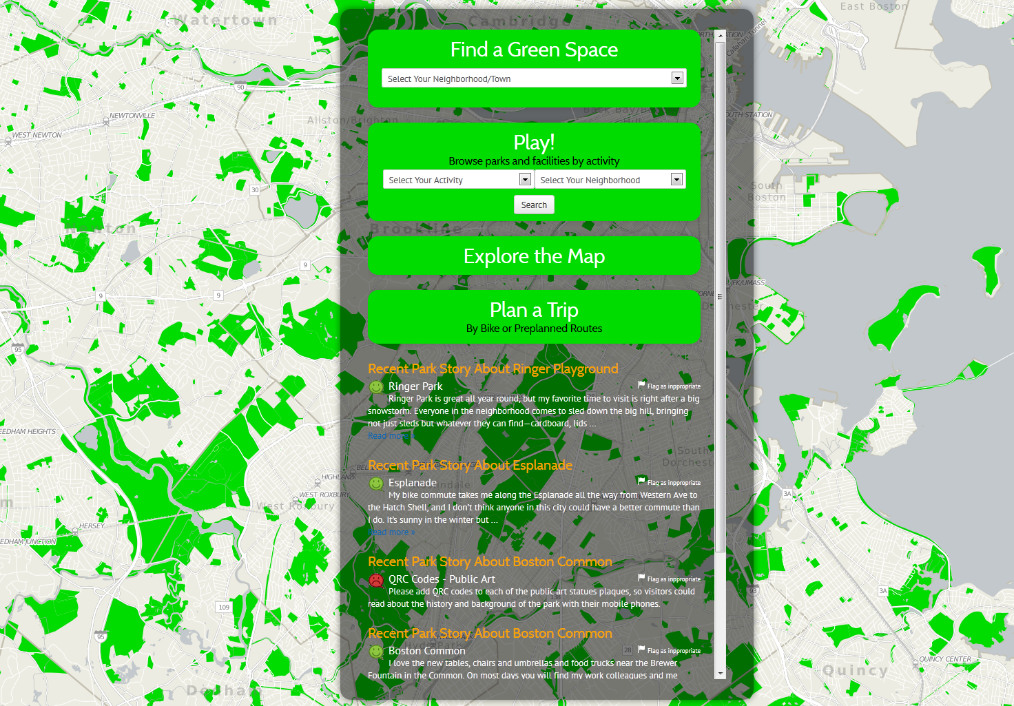
In collaboration with Boston Parks Advocates, MAPC developed an interactive website for Boston area parks (website no longer maintained as of July 2016). Users can search for parks by activity and neighborhood, plan trips, and find biking and walking routes. After they have visited a park, users can share their experiences in the Park Stories section and report any problems with the park to the responsible department. So far, the site covers Boston, Cambridge, Somerville, Belmont, Brookline, Arlington, and Chelsea.
The Urban Waters project, funded by the US Forestry Service, will involve the collection, aggregation, and analysis open space and community garden information for Baltimore City. BNIA-JFI will use this information to create an indicator and interactive mapping website of community gardens in Baltimore City.
In May 2014, D3 launched the 2014 One D Scorecard, an online tool that reports on the status of our region through key data indicators in five Priority Areas: Economic Prosperity, Educational Preparedness, Quality of Life, Social Equity, and Regional Transit. The One D Index also rolls up the over 30 outcome-based indicators composing the five Priority areas into a single comprehensive score to better understand how metro Detroit stacks up across priority areas and other regions overall.
In Spring, 2014 the Dallas Police Department and The Trinity Trust, a local nonprofit, engaged the Institute for Urban Policy Research to assess community perceptions of safety in Dallas public parks and recreation spaces. Through a series of surveys, the public was asked to rate the importance of different quality of life factors based on recreational experiences.
KEEPING WATCH is a three-year initiative designed to foster collaboration across disciplines and interest groups – working with artists, historians, writers, scientists and environmental groups – to engage, inform and inspire the public about better protecting our environment.
By creating a network among a variety of projects going on around these topics, we will engage the public in multiple ways, targeting multiple audiences: through visual arts, public exhibitions, online multimedia presentations, public events and community engagement.
Center on Poverty and Community Development (Cleveland)
November 3, 2015
Image:
In the series "Toxic Neglect", the Cleveland Plain Dealer has been running stories on the problems of lead poisoning on young children. Dr. Robert Fischer, co-director of the Poverty Center, was interviewed for "Lead poisoning makes education harder for kids and teachers" on October 22, 2015.
Center on Poverty and Community Development (Cleveland)
November 4, 2015
Image:
In an editorial to the Cleveland Plain Dealer on November 1, Poverty Center Co-Director Dr. Rob Fischer discussed the magnitude of the problems from lead exposure on young children.
Center on Poverty and Community Development (Cleveland)
March 8, 2016
Image:
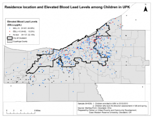
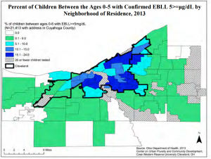
At what level does lead exposure become dangerous for children?
Dr. Robert Fischer, Co-Director of the Poverty Center, and Dr. Elizabeth Anthony, Research Assistant Professor at the Poverty Center, examine this question in The Conversation. In the article, " In kids, even low lead levels can cause lasting harm," Fischer and Anthony discuss how children exposed to levels of lead below the current federal threshold still show cognitive deficits and delays in academic progress.
The Mid-America Regional Council is seeking participation in an important workshop about connecting parks, green spaces, trails, rainwater infrastructure and people within vibrant, healthy, living systems.
Jane Clougherty from the Department of Environmental and Occupational Health at the Dornsife School of Public Health has launched a new project titled "Design and Implementation for Spatially‐Distributed Air Monitoring Campaigns in Philadelphia." The primary goal of thestudy is to design and validate a template for an air monitoring n
Local governments should engage with data intermediary organizations, such as the members of the National Neighborhood Indicators Partnership, to more effectively identify priority issues, find new allies, and devise data-driven policies and programs. In addition to their topical, analytic, and community engagement expertise, these organizations bring an understanding of local context, a reputation for impartial analysis, and a set of relationships that spans sectors. Their services build local capacity, including within governments, to use data for better decisionmaking.
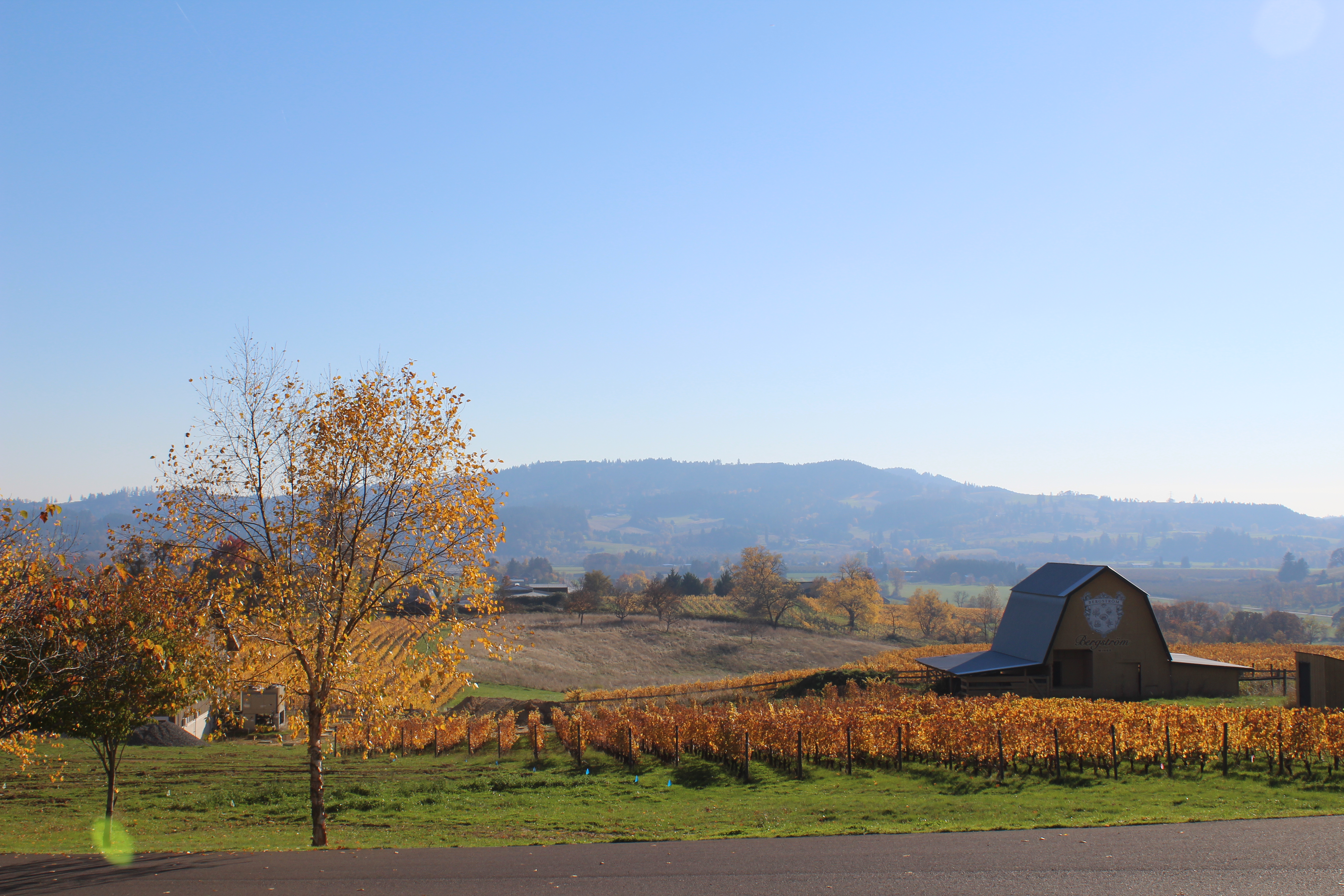
(Inactive) Institute of Portland Metropolitan Studies (Portland)
January 2018
Image:
Metroscape’s Winter 2018 edition launched with a panel discussion on nonagricultural uses of Oregon farmland. View the video here!
This issue also includes stories on urban forestry, school redistricting, and a diverse Portland neighborhood working to improve livability without gentrification.
UHC recently began partnering with Philly Thrive and neighborhood residents on a participatory process to measure air pollution in South Philadelphia. Philly Thrive has been advocating to shut down the Philadelphia Energy Solutions fossil fuel refinery, which was the largest point source of air pollution in the city before the fire there this past June.
Eliminating carbon emissions. Advancing equity and resilience. Public health. Economic growth. How do we align those critical needs? That's what the MAPC Clean Energy Forum dug into on December 11.
MORPC facilitates the planning and development of the region’s multi-use trail network. The Central Ohio Greenways (COG) Regional Trail Vision calls for 500+ new miles of trails to be added to the existing network of over 230 trail miles, resulting in an interconnected network that meets both transportation and recreation needs.
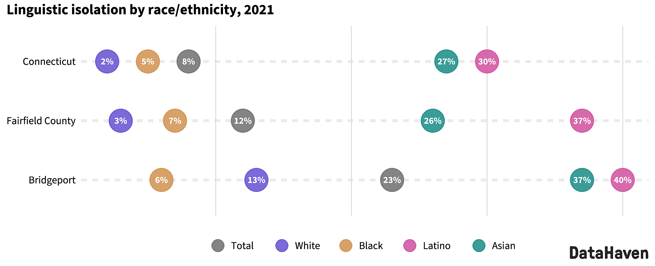
The DataHaven Town Equity Reports provide access to relevant town-level information that is not available from any other source. They use new methods to disaggregate data from the 2020 Census, American Community Survey microdata files, DataHaven Community Wellbeing Survey record-level files from 2015 through 2021, and federal and state agency databases.
Related Links:
2023 Equity Reports for all 169 Connecticut Towns, Join our statewide Advisory Council
Recent research shows trail networks help achieve climate resilience, improve public health, and increase economic prosperity. The Mid-Ohio Regional Planning Commission (MORPC) provided data and analysis to help local governments understand the regional impact of the Central Ohio Greenways (COG) trail system and establish criteria to prioritize trails to fund and build that included equity as a key component.
Data Driven Detroit (D3), Urban Institute, The Data Center
Thursday, September 15, 2022 to Tuesday, December 31, 2024
Over the past two years, the NNIP Network has elevated how local data are critical tools for communities to address the racial wealth gap and improve racial ...
Data Driven Detroit (D3), Urban Institute, The Data Center
Thursday, September 15, 2022 to Tuesday, December 31, 2024
Over the past two years, the NNIP Network has elevated how local data are critical tools for communities to address the racial wealth gap and improve racial ...
Data Driven Detroit (D3), Urban Institute, The Data Center
Thursday, September 15, 2022 to Tuesday, December 31, 2024
Over the past two years, the NNIP Network has elevated how local data are critical tools for communities to address the racial wealth gap and improve racial ...